
A. Coseismic deformation determination
B. Centroid fault-plane solution
C. Source rupture process
D. Landquake characteristic investigations
E. Seismic monitoring of river sediment transport
F. *Landquake dynamic process NEW
_____________________________________________________________________
A. Coseismic deformation determination
An Automatic Scheme for Baseline Correction of Strong-Motion Records in Coseismic Deformation Determination

In this study, we developed an approach based on the ratio of energy distribution in accelerograms as the criterion, to determine the time points of baseline correction automatically, thus avoiding the manual choice of time points and speeding up the estimation of coseismic deformation. Then this approach applied to the 1999 Chi-chi, 2003 Chengkung and 2006 Taitung earthquakes.
Related Program Development:
CoSeismic Deformation
CoSeisD.exe, created by Vvn Weian Chao (request)
Usage: Automatic calculating co-seismic deformation
Platform: Any platform with Fortran
Input: Acceleration data (strong-motion records)
Limitations:
1. instruments with poor performance at long-period portion.
2. coseismic deformation > 1 cm is more robust
_____________________________________________________________________
B. Centroid fault-plane solutions
 With 3D Green's functions and a criterion combining the P-wave polarity and cross-correlations between observed and synthetic waveforms, our new approach provides the better constraint to determine the focal mechanisms and centroid depths of small and moderate events (3.8<Mw<5.6) in Chia-yi earthquake sequence.
Related Program Development:
3D Fault-Plane solution
3D Fault-Plane solution
3DFPs.exe, created by Vvn Weian Chao (request)
Usage: Centroid fault-plane solution by Genetic Algorithem search based on P-waveform similarity and first-motion polarity
Platform: Linux for MPI-fortran parallel computing
Input: Acceleration or velocity seismograms and 3D Green's functions (Graves, 1996 and Olsen et al., 1995) with priori velocity structure
_____________________________________________________________________
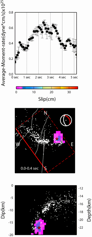
C. Earthquake source rupture process

 Imaging Source Slip Distribution by the Back-projection of P-wave Amplitudes from Strong-motion Records: A Case Study for the 2010 Jiasian, Taiwan, Earthquake.
We developed a new approach to imaging earthquake source rupture process by direct back-projection local P-wave amplitudes from real-time strong-motion records. Our study is the first back-projection application to local earthquake in Taiwan.
Related Program Development:
Local P-wave Back-Projection Method
PBPM.exe, created by Vvn Weian Chao (request)
Usage: imaging source slip distribution by back-projection of local P-wave amplitude
Platform: Any platform with Fortran
Input: Acceleration or velocity seismograms, priori velocity structure, hypocentral location and earthquake magnitude (loaction and magnitude are not necessary)
_____________________________________________________________________
D. Landquake characteristic investigations
A Seismological Study of Landquakes Using a Real-Time Broadband Seismic Network.

We detected 12 landquakes in Taiwan with collapse areas between 0.27 and 2.48 kmxkm during the passage of Typhoon Morakot in 2009. Their centroid locations were determined by cross-correlation technique that maximizes the coherency of horizontal envelope function among seismic stations with a mean location error of 1.92 km. We applied time-frequency analysis to investigate the characteristics of the landquake-induced seismic signal.
A Seismological Study of Landquakes Using a Real-Time Broadband Seismic Network.
Related Program Development:
Spectrogram from Short-Time window Fourier Transform or S-Transform, also for group velocity analysis
Spectrogram from Short-Time window Fourier Transform or S-Transform, also for group velocity analysis
stft_st_grp.exe, created by Vvn Wei Chao (request)
Usage: Time-frequency analysis
Platform: Any platform with Fortran
Input: any type time series
Landquake Epicenter Determination
LED.exe, created by Vvn Weian Chao (request)
Usage: determining centroid location of landquakes using cross-correlation between horizontal eveolope functions.
Platform: Any platform with Fortran
Input: Acceleration or velocity seismograms, priori S-wave velocity structure, topography data (default: Taiwan 40m)
_____________________________________________________________________
E. Seismic monitoring of river sediment transport
 Seismologically determined bedload flux during the typhoon season.

Continuous seismic records near river channels can be used to quantify the energy induced by river sediment transport. During the 2011 typhoon season, we deployed a seismic array along the Chishan River in the mountain area of southern Taiwan, where there is strong variability in water discharge and high sedimentation rates. We observe hysteresis in the high-frequency (5-15 Hz) seismic noise level relative to the associated hydrological parameters. In addition, our seismic noise analysis reveals an asymmetry and a high coherence in noise cross-correlation functions for several station pairs during the typhoon passage, which corresponds to sediment particles and turbulent flows impacting along the riverbed where the river bends sharply. Based on spectral characteristics of the seismic records, we also detected 20 landslide/debris flow events, which we use to estimate the sediment supply. Comparison of sediment flux between seismologically determined bedload and derived suspended load indicates temporal changes in the sediment flux ratio, which imply a complex transition process from the bedload regime to the suspension regime between typhoon passage and off-typhoon periods. Our study demonstrates the possibility of seismologically monitoring river bedload transport, thus providing valuable additional information for studying fluvial bedrock erosion and mountain landscape evolution.
Seismologically determined bedload flux during the typhoon season.
Continuous seismic records near river channels can be used to quantify the energy induced by river sediment transport. During the 2011 typhoon season, we deployed a seismic array along the Chishan River in the mountain area of southern Taiwan, where there is strong variability in water discharge and high sedimentation rates. We observe hysteresis in the high-frequency (5-15 Hz) seismic noise level relative to the associated hydrological parameters. In addition, our seismic noise analysis reveals an asymmetry and a high coherence in noise cross-correlation functions for several station pairs during the typhoon passage, which corresponds to sediment particles and turbulent flows impacting along the riverbed where the river bends sharply. Based on spectral characteristics of the seismic records, we also detected 20 landslide/debris flow events, which we use to estimate the sediment supply. Comparison of sediment flux between seismologically determined bedload and derived suspended load indicates temporal changes in the sediment flux ratio, which imply a complex transition process from the bedload regime to the suspension regime between typhoon passage and off-typhoon periods. Our study demonstrates the possibility of seismologically monitoring river bedload transport, thus providing valuable additional information for studying fluvial bedrock erosion and mountain landscape evolution.
Related Program Development:
Seismic Noise level
Seismic Noise level
SeisNoise.exe, created by Vvn Weian Chao (request)
Usage: Calculate "RIVER" seismic noise from 1-day continuous seismogram
Platform: Any platform with Fortran
Input: any type time series with 1-day SAC format
 Figure. General source
inversion (GSI) and landquake dynamics for Shiaolin event. (a) Examples of fits at two
stations between records (black) and synthetic seismograms calculated for
different source mechanisms including landquake force history (LFH, red),
single force (SF, blue), and full moment tensor (MT) and its deviatoric moment
tensor (CLVD+DC), double couple (DC), and isotropic (ISO) components plotted
with different gray levels. All waveforms are filtered to 0.025-0.05 Hz, and
the fitness values are typically between 0.746 and 1.421. The normalized
cross-correlation coefficient (CC) and variance reduction (VR) are given at the
end of each synthetic trace. The station name, epicentral distance, and station
azimuth are given at the top. (b) Inferred collapsed-mass trajectory. The
colored region shows the collapse area of the Shiaolin event mapped by the
Central Geological Survey of Taiwan. Color dots indicate the locations of the
center of collapsed-mass along run-out path trajectory. The black dot shows the
transition spot from acceleration to deceleration. (c) LFH of each component
(green: north; blue: east; red: down) and the absolute value of the force
vector (dashed line). Time-dependent force vectors acting on the Earth are
shown in the right panel. (d) Filtered horizontal envelope functions recorded
at the closest Station SGSB. Open circles depict the peak ground velocity (PGV)
and peak amplitude of D-phase (PAD).
The dashed arrow shows the smooth decay of short-period seismic signals. All
color dots correspond to those in (b) of the same color during the time
progression from 0 to 100 sec in the LFH result. The vertical dashed lines
indicate the onset of maximum acceleration (ta),
maximum deceleration (td),
and dam-forming phase (D-phase),
respectively.
Figure. General source
inversion (GSI) and landquake dynamics for Shiaolin event. (a) Examples of fits at two
stations between records (black) and synthetic seismograms calculated for
different source mechanisms including landquake force history (LFH, red),
single force (SF, blue), and full moment tensor (MT) and its deviatoric moment
tensor (CLVD+DC), double couple (DC), and isotropic (ISO) components plotted
with different gray levels. All waveforms are filtered to 0.025-0.05 Hz, and
the fitness values are typically between 0.746 and 1.421. The normalized
cross-correlation coefficient (CC) and variance reduction (VR) are given at the
end of each synthetic trace. The station name, epicentral distance, and station
azimuth are given at the top. (b) Inferred collapsed-mass trajectory. The
colored region shows the collapse area of the Shiaolin event mapped by the
Central Geological Survey of Taiwan. Color dots indicate the locations of the
center of collapsed-mass along run-out path trajectory. The black dot shows the
transition spot from acceleration to deceleration. (c) LFH of each component
(green: north; blue: east; red: down) and the absolute value of the force
vector (dashed line). Time-dependent force vectors acting on the Earth are
shown in the right panel. (d) Filtered horizontal envelope functions recorded
at the closest Station SGSB. Open circles depict the peak ground velocity (PGV)
and peak amplitude of D-phase (PAD).
The dashed arrow shows the smooth decay of short-period seismic signals. All
color dots correspond to those in (b) of the same color during the time
progression from 0 to 100 sec in the LFH result. The vertical dashed lines
indicate the onset of maximum acceleration (ta),
maximum deceleration (td),
and dam-forming phase (D-phase),
respectively.
invert bedload flux (qb) based on seismic vertical impact model
invq, created by Vvn Weian Chao (request)
Usage: Invert bedload flux by using the observed PSD amplitude
Platform: Any platform with Fortran
Input: Flow depth (H), grain size distribution, velocity structure, seismic quality factor, river geometry
_____________________________________________________________________
F. Landquake dynamic process
Seismology-based early identification of dam-formation landquake events
In this study, we conduct inversions of long-period (LP, period ≥ 20 sec) waveforms for the landquake force histories (LFHs) of ten events, which provide quantitative characterization of the initiation, propagation and termination stages of the slope failures. When the results obtained from LP waveforms are analyzed together with high-frequency (HF, 1-3 Hz) seismic signals, we find a relatively strong late-arriving seismic phase (dubbed Dam-forming phase or D-phase) recorded clearly in the HF waveforms at the closest stations, which potentially marks the time when the collapsed masses sliding into river and perhaps even impacting the topographic barrier on the opposite bank. Consequently, our approach to analyzing the LP and HF waveforms developed in this study has a high potential for identifying five dam-forming landquake events (DFLEs) in near real-time using broadband seismic records, which can provide timely warnings of the impending floods to downstream residents.Seismology-based early identification of dam-formation landquake events

Related Program Development:
Landquake Force History
General Source Inversion
GSI, created by Vvn Weian Chao (request)
Usage: A flexible approach to full-waveform inversion is developed in this study, which models the seismic source as a full moment tensor (MT), pure double couple (DC), explosion isotropic source (ISO) and a single-force (SF)
Platform: Any platform with Fortran
Input: velocity seismograms and 1D Green's functions (FK method, Zhu & Rivera, 2002) with priori velocity structure, landquake location
Landquake Force History
LFH, created by Vvn Weian Chao (request)
Usage: This program is for inversion of landslide force history. To solve for the amplitudes of the triangles that define the time histories of each component of the force by minimizing, in a least-squares sense, the misfit between observed and corresponding synthetic seismograms.
Platform: Any platform with Fortran
Input: velocity seismograms and 1D Green's functions (FK method, Zhu & Rivera, 2002) with priori velocity structure, landquake location